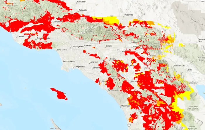
The California Fire Department released the latest round of fire hazard maps today, showing that the number of areas in the state vulnerable to wildfires has increased significantly since 2011. The area of high-risk and extremely high-risk zones (marked in orange and red) amounts to 3,626 square miles, approximately twice the size of Delaware, covering nearly 3.7 million residents. Residents in these areas need to comply with stricter building codes, fire prevention measures and property disclosure regulations, which may have a profound impact on the housing market and community planning.
The update of the new map reflects the impact of climate change, more precise modeling techniques and changes in legal requirements. California Fire Chief Daniel Brandt emphasized that these maps are designed to help communities enhance their disaster resilience rather than directly influencing insurance policies. However, homeowners are still concerned about rising insurance costs and property depreciation, especially in fire-prone areas such as Lake County and Auburn.
Although the map offers a more comprehensive risk assessment, some experts believe that it may still underestimate the actual dangers, such as not fully reflecting the risk of fire spread in the urban fringes. In the future, California may need to further optimize the model, incorporating factors such as building density and road layout, in order to more accurately predict the impact of catastrophic fires.
Related Topic:


